Showing 69 items matching survey camp
-
 Falls Creek Historical Society
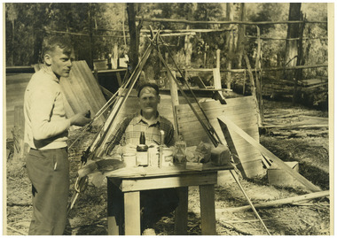
Photograph - Big River Survey Camp, c1949
... Big River Survey Camp...Big River Survey Camp...Two black and white images at the Big River Old Survey Camp...., Wal Johnson Photo 2 - Big River Survey Camp at foot of T Spur... Johnson Photo 2 - Big River Survey Camp at foot of T Spur C 1949 ...MEYER COLLECTION - FALLS CREEK PHOTOS In 1947 a determined group of like-minded State Electricity Commission (SEC) staff including Ray Meyer, the chief surveyor of the Kiewa Hydro-Electric Scheme, had a common interest that revolved around the skiing potential of the snow-covered high plains which included what is now the resort of Falls Creek. The six SEC employees, Toni St Elmo, Ray Meyer, Jack Minogue, Lloyd Dunn, Adrian Ruffenacht and Dave Gibson (together with their families) banded together to secretly build a 'hut' that was the first ski lodge at Falls Creek. Using a road built in 1930s to gain access to Falls Creek, their hut project was carried out in secret as efforts by other skiers were blocked by H.H.C. Williams – the engineer in charge of the Hydro Scheme. In 1946 Ray Meyer made a trip to the Lands Office in Melbourne. He came away with a 99-year lease on three acres that was ideally suited for a hut designed by Lloyd Dunn. Adrian Ruffenacht (Design Engineer for the KHS) had suggested where the group should build because of easy access to a spring for water. Much of the building material required was scavenged from derelict huts on the high plains. Due to the need for secrecy, the determined group worked on the hut in the evenings and weekends to avoid detection. During the building period the group had met at Echidna Rock (now known as Eagle Rock) where Skippy St Elmo announced, "This is my favourite ‘Skyline’.” And so the first lodge in the area at Falls Creek Ski Resort came into existence. With the development of the International Poma in the 1970s, the Skyline Lodge, which was sited between the ski-lift’s pole one and pole two, was demolished. However, the legacy of Ray Meyer, Toni St Elmo, Jack Minogue, Lloyd Dunn, Adrian Ruffenacht and Dave Gibson and Skyline lives on in the vibrant atmosphere of Falls Creek Resort. The MEYER COLLECTION documents developments on the Kiewa Hydro Scheme and their life at Falls Creek from the mid 1930s to 1960s.This image is significant because it documents development of the Kiewa Hydroelectric Scheme.Two black and white images at the Big River Old Survey Camp.Photo 1 - Breakfast at Big River Left to RIght Ray Meyer, Wal Johnson Photo 2 - Big River Survey Camp at foot of T Spur C 1949, Kiewa RIver Survey Team.kiewa hydroelectric scheme, ray meyer, wal johnson -
 Otway Districts Historical Society
Photograph, Railway survey camp, c.1901
... Railway survey camp, c.1901...survey camp; beech forest; railways;...Photograph, B/W. Railway survey camp, Beech Forest line.... Forest great-ocean-road Photograph Railway survey camp, c.1901 ...Six surveyors and a horse posing outside five tents somewhere on the Beech Forest line in approximately 1901.Photograph, B/W. Railway survey camp, Beech Forest line.survey camp; beech forest; railways; -
 Otway Districts Historical Society
Photograph, Railway Survey Camp, Beech Forest, 4 Apr 1897, 4 April 1897
... Railway Survey Camp, Beech Forest, 4 Apr 1897...Photograph, Railway Survey Camp, 4 April 1897. Inspection... Forest great-ocean-road Photograph Railway Survey Camp, Beech ...On the 18th August, 1896, the question of selecting localities for the permanent survey of a narrow-gauge line to Beech Forest from Colac was mooted. Two potential lines were examined. In a memorandum to the Minister for Railways, dated 23rd March, 1897, the Engineer-in-Chief recommended that the eastern and longer route via Lardner's Track be adopted. The second route, while identical from Colac to Gellibrand River, differed. By a more direct route the Beech Forest terminus is reached 5 miles sooner and cost approximately L24,500 less. The direct line would also serve a larger lot of settlers and would obtain a larger lot of traffic than the alternate proposal. The Parlimentary Standing Committee on Railways examined the proposal in situ and recommended that the direct route from Gellibrand to Beech Forest should be adopted and the Lardner's Track route should be abandoned at once.Photograph, Railway Survey Camp, 4 April 1897. Inspection of alternative routes by Parliamentary Committee on Railways.People named in the photograph.beech forest; railway; survey; victorian parliament; calcutt; fraser; e.h. cameron; d. mciville; a. harris; n. mcinnes; j.s. white; j. wood; t. baker; j. gardner; t.g. watson; standing committee; -
 Ballarat Heritage Services
Photograph, Transcontinental Railway Survey Camp, c1905
... Transcontinental Railway Survey Camp...survey camp... Office goldfields Photograph Transcontinental Railway Survey Camp ...Photograph of a camel team on the Transcontinental Railway, which runs from Adelaide to Darwin.the ghan, trans continental railway, survey camp -
 Otway Districts Historical Society
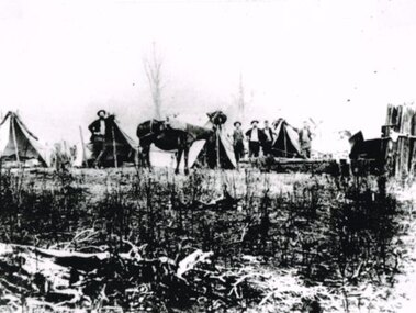
Photograph, Knox Collection, Survey camp for Colac-Beech Forest railway, 1901
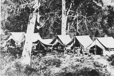
... Survey camp for Colac-Beech Forest railway, 1901....B/W. Survey camp for the Colac-Beech Forest railway in 1901... Forest great-ocean-road Photograph Survey camp for Colac-Beech ...Plans for a rail connection between Colac and Beech Forest had been drawn up in 1884 and 1889 but proofed inconclusive because of the enormous cost involved in building a railway in such difficult terrain. Because of the financial depression in the early 1890s such expenditure went of hold. Towards the end of the decade planners recognised that a narrow gauge could be a viable alternative and it was taken up by the community, Parliamentary representatives and the government, although Victorian Railways administration was against the idea. This was overridden. The 1898 Parliament approved a 2 foot 6 inch gauge from Colac to Beech Forest although strict financial limits were set. The route was to be the most direct and the infrastructure the most basic. Construction began in 1900 entailing very steep grades and myriad curves until it finished in 1902. Surveyors and their assistants came before and during the track laying for the whole distance.B/W. Survey camp for the Colac-Beech Forest railway in 1901, showing nine tents, ten men including a cook, survey instruments, and three bicycles. Note the cooking fire on the right.colac: beech forest; railways; survey; -
 Orbost & District Historical Society
black and white photograph, July 27 1907
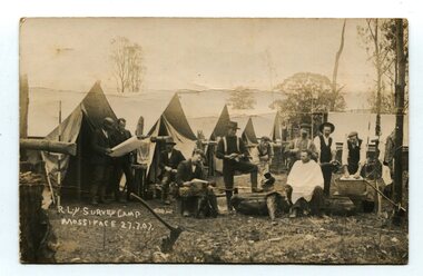
... surveying-railway east-gippsland-railway mossiface-survey...This is a camp of survey workers surveying the railway line...on front - handwritten is " R.L.Y.S. SURVEY CAMP MOSSIFACE... is " R.L.Y.S. SURVEY CAMP MOSSIFACE 27.7.07" on back is a letter ...This is a camp of survey workers surveying the railway line . They were camped at Mossiface in 1907. It has been sent as a postcard - "Dear Miss Ross, Just a card, hoping you are well etc, trust you have not forgotten our trip. I forgot to get the name of the street in Hobart of Mr Benjamin or Temple?????? Sufficient. Yours sincerely H.R. Gordon". It has been dated September 30th 1907. There had been men surveying in East Gippsland from the late 19th century. Railway surveyors advocated two lines beyond Bairnsdale – one via Bruthen and the Tambo Valley to Omeo, the other via Swan Reach and Colquhoun to Orbost, then on to Bendoc and the border. With all the argument and feuding between the warring factions, by the end of 1891, the Parliamentary Railways Standing Committee gave up in despair of trying to reach any agreement and abandoned the idea altogether. Finally, with all problems solved, the first sod was turned at Mossiface on 9.1.1912, the government sticking to the original route in the 1890 survey .This is a pictorial record of a surveyors' camp in the early 20th century. The Bairnsdale to Orbost Railway was a significant contributor to the economy of Orbost until it closed.A black / white photograph / postcard of a group of men at a campsite. In the background is a row of tents. on the right side is a clothes line with several sheets hung over it. Two men are studying a map or chart; one man is sitting with a cloth around his shoulders while another is standing behind him cutting his hair; one man is washing cloth in a tin tub; another appears to be stirring a pot; others are sitting reading or just observing.on front - handwritten is " R.L.Y.S. SURVEY CAMP MOSSIFACE 27.7.07" on back is a letter - "Dear Miss Ross.............yours sincerely ????? Gordon"surveying-railway east-gippsland-railway mossiface-survey-camp -
 Halls Gap & Grampians Historical Society
Photograph - B/W
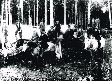
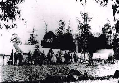
... Railway survey camp 1880 After choosing the route, the rail...Railway survey camp Heatherlie quarry; 11 men, some... Railway survey camp Heatherlie quarry; 11 men, some standing, some ...Railway survey camp 1880 After choosing the route, the rail survey was undertaken followed by the construction of the line in less than a year. By Nov 1881 access by rail for Heatherlie to Melbourne was a reality Railway survey camp Heatherlie quarry; 11 men, some standing, some reclining in front of 6 army style tentsstructures, tents -
 Tatura Irrigation & Wartime Camps Museum
Audio Tape, Walking tour of Camp 1 with Jenny Dumble who conducted an archaelogical survey thereof, 1990
... completed an archaeological survey of the camp remains. Members of T.... Jenny Dumble archaeological survey Camp remains ...Walking tour of camp 1 with Jenny Dumble who had just completed an archaeological survey of the camp remains. Members of T & D Historical Society accompanied.audio tape 90 minutesCamp 1 Jenny Dumblejenny dumble, archaeological survey, camp remains -
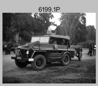
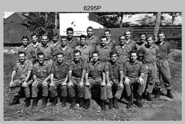
 Bendigo Military Museum
Photograph - Bell 47G-2 helicopter used in Royal Australian Survey Corps Field Operations, c1965
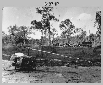
... at a field survey camp. The left-hand vehicle is a Willys Jeep..., Bell 47G-2 helicopter: VH-UTB with survey camp in background... helicopter: VH-UTB with survey camp in background. .2) - Photo ...This is a set of four photographs of Bell 47G-2 helicopters used in Royal Australian Survey Corps Field Operations. c1965. From 1957, helicopter transport of survey parties revolutionised transport in remote areas. The most common helicopter used by the Royal Australian Survey Corps at this time was the civilian Bell 47G-2 and the Sioux, the Australian Army’s equivalent. From 1964 an Aerodist MRC2 airborne Electronic Distance Measuring (EDM) system was extensively used for topographic surveys over long distances by trilateration to replace traverse requiring survey station intervisibility. In 1965 the command field survey unit personnel attached to the Army Survey Regiment’s Topographic Squadron were used mainly in support roles such as station clearing, tower operations, station monumenting, Aerodist computations, forward base operations, geodetic observations on the north-south traverse and logistic support for Remote teams. .1P is a photo of a civilian Bell 47G-2 helicopter Registration / Serial VH-UTB owned by Helicopter Utilities from Mascot, NSW c1965. In the background of this photograph is three personnel and vehicles at a field survey camp. The left-hand vehicle is a Willys Jeep with trailer and on the right is probably a Truck, 2 1/2 ton, 6x6, General Service GMC. The Bell 47G-2: VH-UTB was destroyed, and its pilot killed in tragic circumstances during a civilian survey operation on Cape York Peninsula in June 1966. .2P is a photo of a a civilian Bell 47G-2 helicopter Registration / Serial VH-IHB taken in Wyndham, WA. As the letters ‘TAA’ appear on the fuselage, the helicopter was charted from Trans Australian Airways. .3P is a photo of a Bell 47G-2: VH-UTC with survey camp in background. .4P is a photo of a Bell 47G-2 equipped with floats and unidentified personnel loading stores, possibly in Darwin. Acknowledgement: Royal Australian Survey Corps – Aerodist Years 1964-1975 Version 2021.0 Authored by Peter Jensen.This is a set of four photographs of civilian Bell 47G-2 helicopters used in Royal Australian Survey Corps Field Operations. c1965. The photographs were printed on photographic paper and are part of the Army Survey Regiment’s Collection. The photographs were scanned at 300 dpi. .1) - Photo, black & white, c1965, Bell 47G-2 helicopter: VH-UTB with survey camp in background. .2) - Photo, black & white, c1965, Bell 47G-2 helicopter: VH-IHB with survey station in foreground. .3) - Photo, black & white, c1965, Bell 47G-2 helicopter: VH-UTC with survey camp in background. .4) - Photo, black & white, c1965, Bell 47G-2 helicopter: Unidentified personnel loading stores possibly in Darwin..2P – annotated on bottom of photo ‘Wyndham Area – Helicopter drops observing party’ The other photographs are not annotated.royal australian survey corps, rasvy, army survey regiment, army svy regt, fortuna, asr, surveying -
 Federation University Historical Collection
Letter, Ballarat School of Mines, 1908
... tongalla survey camp... of victoria tongalla survey camp ballarat fine art gallery association ...October inwards correspondence for the Ballarat School of Mines. * School of Mines and Industries, Bendigo (certification of Mine Managers) * Telegram - examination papers * Commonwealth telegram - Ballarat School of Mines battery availability for crushing ten tons. * Letterhead from the Roneo Co., Melbourne * J. Donald of Wallace St, Toorak * Letterhead from York Chambers, 49 Queen Street, Melbourne - signed J. Kaufmann * Letterhead from Cochran & Co - re Cocnran boilers * Letterhead of Thames School of Mines, New Zealand * Letter re James Chambers missing school from his father James Chambers Snr of Talbot * Education Department Circular * letter signed by F.W. Calaby * F.W. Silberberg & Co re crucibles * Letterhead of New Black Horse Mining Company - signed E. Howell * Australasian Institute of Mining Engineers, 57-59 Swanston Street, Melbourne - signed D.L. Stirling * Letterhead of John F. Paterson * Letterhead of the Welcome Stranger Dredging Company, Dunolly - W.J. Parker manager * Letterhead of Nevett and Nevett Barristers and Solicitors, Lydiard Street, Ballaarat * John Barker, H. Barbour * Telegram re Brearley Lyndhurst * Letterhead of the Commonwealth Minerals Co - John F. Paterson, Legal Manager * Query re courses at the Ballarat School of Mines - A. O'Mara * Stone to be crushed, Egerton from J.H. Davidson * Letterhead from 'Terascoa' Port Kembla signed by W.S. Macartney * Letter from Thomas Williams * Letterhead from Australian Institute of Mining Engineers regarding excursion to Toongabbie and Walhalla - Signed D.L. Stirling * Assay from George Brearley of Lyndhurst via Scottsdale * Letterhead of Berry United Deep Leads Limited, Ulina * Embossed leather classes for coachwork from S. Mee of Clunes * The Lord Nelson North Gold Mning Company No Liability signed by Edward H. Shackell * Correspondence from May Consolidated Gold Mining Company, Transvaal signed by Jason Hawthorne * Letterhead of the Northern Assurance Company, 448 Collins St, Melbourne * Letter fom James Lidgett of "Braelands" Myrniong * Gordon sides asking for a reference * Letterhead of Fraser & Chalmers Ltd, Manufacturersw of mining machinery, steam engines, boilers and machinery for systematic milling, smelting and concentration of ores, signed by W.R. Caithness * Letterhead of the Board of Examiners for Engine-Drivers, signed by R. Birrell * Letter concerning outstanding amount due to theBallarat East School of Design, signed by Edward Reid, Manager * Letterhead of the Ballarat Public Library concerning an outstanding amount in the School of Design Account. * Letterhead of the A. Gallenkamp and Co. regarding their new catalogue * Letterhead from the Creswick Advertiser, Albert Street, Creswick * Handwritten letter from John Brittain inviting Ballarat School of Mines students to join him at the telescope weather permitting * Letterhead of Victorian Railways, signed by E.B. Jones * Letterhead of the Ballarat East Town Clerk's Office * Letterhead of Elliott, Maclean and Co. Handwritten letter re Dressmaking from J.H. Wrightrand, south africa, kalgoorlie, school of mines and industries, bendigo, certification of mine managers, bendigo school of mines, telegram, ballarat school of mines battery, roneo co., melbourne, j. donald, york chambers, cochran & co, thames school of mines, new zealand, james chamberseducation department circular, f.w. calaby, * f.w. silberberg & co, crucibles, new black horse mining company, e. howell, * australasian institute of mining engineers, john f. paterson, welcome stranger dredging company, dunolly, w.j. parker, nevett and nevett, john barker, h. barbour, brearley lyndhurst, commonwealth minerals co, a. o'mara, j.h. davidson, 'terascoa' port kembla, w.s. macartney, thomas williams, australasian institute of mining engineers, excursion, toongabbie, walhalla, d.l. stirling, george brearley, lyndhurst via scottsdale, berry united deep leads limited, ulina, embossed leather classes for coachwork, s. mee, clunes, the lord nelson north gold mning company no liability, edward h. shackell, may consolidated gold mining company, transvaal, jason hawthorne, northern assurance company, james lidgett, "braelands" myrniong, gordon sides, fraser & chalmers ltd, mining machinery, w.r. caithness, examiners, ballarat east school of design, edward reid, ballarat public library, school of design, a. gallenkamp and co., creswick advertiser, john brittain, telescope, victorian railways, e.b. jones, ballarat east town clerk's office, elliott, maclean and co., dressmaking, j.h. wright, ausimm, berry united, school of mines and industries bendigo, lyndhurst tasmania, may consolidated gold co germiston transvaal, transvaal, germiston, roneo, thames school of mines, schools of mines, welcome stranger dredging co, cowley copper development syndicate ltd, department of mines, maryborough school, pharmacy board of victoria, tongalla survey camp, ballarat fine art gallery association, central microscopical -
 Orbost & District Historical Society
book, 1922
... Esquire Survey Camp Tubbut" and three stamps.... Esquire Survey Camp Tubbut" and three stamps. William Hunter (1893 ...William Hunter (1893-1971), resident of Tatura and Mallacoota was a soldier, surveyor and amateur naturalist.This item is associated with William Hunter.A black covered book of astronomical observations and results handwritten on lined pages. Inside is a blotter - "Reed Bros Tomato Sauce" ; an envelope addressed to "William Hunter Esquire Survey Camp Tubbut" and three stamps.hunter-william astronomy science -
Tatura Irrigation & Wartime Camps Museum
Book, Adolf Wilke, 15 September 1944 - 1 May 1946
... in surveying at Camp 13, Murchison.... in surveying at Camp 13, Murchison. Adolf Wilke Surveying Camp 13 ...Surveyors book compiled by POW Adolf Wilke who was lecturer in surveying at Camp 13, Murchison.Handmade hard cover, hand stitched book consisting of figures and plans in ink and pencil. 69 numbered pages.adolf wilke, surveying, camp 13 surveying -
 Orbost & District Historical Society
black and white photograph, C1880s -1 890s
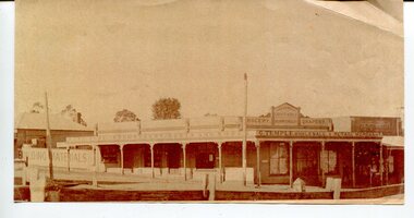
... to the survey camp. George Temple, born in Yorkshire on 26/2/1832... are on their way to the survey camp. George Temple, born in Yorkshire on 26 ...This photograph shows George Temple's store which began operating C1888 opposite the post office in the main street of Orbost. The store stocked other stores at Bendoc supplying the gold fields. The men with their pack horses are on their way to the survey camp. George Temple, born in Yorkshire on 26/2/1832 was of the earliest Orbost storekeepers. Temple's Store was on the corner of Ruskin and Nicholson Streets opposite the post office. He packed stores to the Bendoc area goldfields. The store building eventually became part of Herbert's store when he died in 1917. This item is associated with the very early history of Orbost. George and Mary Temple were early shopkeepers who operated a store opposite the Post Office for many years. Their daughters were very talented women.A black / white photograph of low set wooden buildings . In the foreground is a fence on the opposite side of the street. There are signs on the top part of the building which occupies the whole corner - "G. TEMPLE Wholesale & Retail Merchant, Building materials, furniture, ironmomgery, boots and shoes, grocery, drapery, Croajingalong General Store, The Orbost Equitable Grocery"orbost-19th-century temple-george retail-stores -
 Orbost & District Historical Society
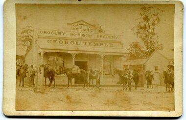
black and white photograph, C1900
... to the survey camp. George Temple, born in Yorkshire on 26/2/1832... are on their way to the survey camp. George Temple, born in Yorkshire on 26 ...This photograph shows George Temple's store which began operating C1888 opposite the post office in the main street of Orbost. The store stocked other stores at Bendoc supplying the gold fields. The men with their pack horses are on their way to the survey camp. George Temple, born in Yorkshire on 26/2/1832 was one of the earliest Orbost storekeepers. Temple's Store was on the corner of Ruskin and Nicholson Streets opposite the post office. He packed stores to the Bendoc area goldfields. The store building eventually became part of Herbert's store when he died in 1917.This item is associated with the very early history of Orbost. George and Mary Temple were early shopkeepers who operated a store opposite the Post Office for many years. Their daughters were very talented women.A faded black / white photograph of men with pack horses standing outside George Temple's store, The Orbost Equitable, in the main street. It is on a cream coloured buff card.temple-george-orbost gold-fields-bendoc -
 Kiewa Valley Historical Society
Photographs and copies of photographs of the pack horses and early horsemen who transported supplies to outposts in the Bogong High Plains, via cattle tracks before access roads were made
... , transporting supplies and correspondence to the outlying camps... – Survey Camp at Young’s Hut ... supplies and correspondence to the outlying camps and survey posts ...In the mid to late 1930’s survey outposts were established to plot the early stages of the Kiewa Hydro Electric System for the SECV in the Bogong High Plains. Before any roads were built, the old cattleman’s tracks were used with packhorses to deliver supplies, wages and mail and collect timesheets and correspondence from the workmen and dam builders living in canvas tents and at the outlying survey posts. The trip up the mountain was long and hard and dangerous for both horse and man Most of the men of the survey teams were not bush-men and were often ill equipped for the harsh weather and living conditions of bush camping, often arriving in their city clothes ready for work. The tent city at Bogong was destroyed by bush fires in 1939 after which an access road was built from Mt Beauty to transport building materials for more permanent dwellings for workmen. Pack horses continued to be used for transporting goods etc. to workers further up the mountain.Without the work of horsemen and their pack horses providing supplies and communications for outlying outposts, surveying and early planning for the Kiewa Valley Hydro Electric scheme could not have gone ahead and the dams and power stations which support the system could not have been constructed. The Hydro-electric scheme, and the workers who planned and built it play a major part in the early history of the Kiewa Valley and many original families still remain living, or have ties with the local area.: Set of 21 black and white photographs and copies of photographs depicting the pack horses and the men who handled them, transporting supplies and correspondence to the outlying camps and survey posts in the Bogong High Plains, via the rough cattlemen’s tracks. Photographs also show the early tent camps of the workers. Some photos mounted on A4 white paper. Some photos enlarged to A3 poster size for display1. Handwritten on back – Max Lawrence 2. -8 No inscriptions 9. Handwritten on back- Packing in supplies for early workers of the Kiewa Hydro scheme. There were no roads in the early days of the scheme 10. Printed on bottom of photo- Roper’s cattle on road below Howman’s Gap 11. Handwritten on back – Roper’s et al about to leave for the high plains 12. Printed under photo- Syd Ryder at the Pretty Valley Cut-Out (JBR) 13-16. No markings 17. Printed under photo- Gwen Talbot visits the Camp area. 1937 18. Handwritten on back- 14/1 Barbara Talbot 19. No markings 20-21. No markings 22. Printed under photo- STATE ELECTRICITY COMMISSION OF VICTORIA. Date: 15-3-45 Time: 8.0pm No: K 1838 Kiewa Hydro-Electric Works, Investigations 1944-1945 – Survey Camp at Young’s Hut pack horses; bogong high plains; survey posts; supplies delivery -
 Bendigo Military Museum
Photograph - Royal Australian Survey Corps Field Survey Vehicles, c1950s
... Lockwood and CAPT Jim Stedman was taken at a field survey camp... Lockwood and CAPT Jim Stedman was taken at a field survey camp ...This is a set of five photographs of vehicles used by field survey parties. c1950s. The first two photos show unidentified surveyors and field survey vehicles departing the Army Survey Regiment’s transport compound. The third photo of LTCOL Lindsay Lockwood and CAPT Jim Stedman was taken at a field survey camp at Camooweal, QLD. LTCOL Lindsay Lockwood was the CO of the Army Survey Regiment from 1951 to 1962. As the longest serving commanding officer of the unit, there was many changes implemented. LTCOL Lindsay Lockwood’s period as CO is covered in more detail in pages 48-49 of Valerie Lovejoy’s book 'Mapmakers of Fortuna – A history of the Army Survey Regiment’ ISBN: 0-646-42120-4. CAPT Jim Stedman later reached the rank of Colonel, was Director of Military Survey from 1975 to 1978 and was appointed as Colonel Commandant (honorary appointment, Retd) of the Royal Australian Survey Corps from 1978 to 1983. The truck and semi-trailer loaded on a flatbed Photo .4P was probably towing RA Svy’s field deployable printing press, the MANN Double Crown. See pages 44 -45 of Valerie Lovejoy’s book for more information on how this trailer mounted printing press was used in a recruitment drive in 1948.This is a set of five photographs of vehicles used by field survey parties. c1950s – 1960s. The photographs were printed on photographic paper and are part of the Army Survey Regiment’s Collection. The photographs were scanned at 300 dpi. .1) - Photo, black & white, c1950s, unidentified surveyors in a field survey vehicle departing the Army Survey Regiment’s transport compound. .2) - Photo, black & white, c1950s, unidentified surveyors in a Humber 1 ton survey vehicle departing the Army Survey Regiment’s transport compound. .3) - Photo, black & white, 1958, L to R: LTCOL Lindsay Lockwood and CAPT Jim Stedman at Camooweal, QLD., .4) - Photo, black & white, c1950s, unidentified surveyor, field survey truck and trailer. .5) – Photo black & white, c1950s. Unidentified surveyor undertaking vehicle recovery..3P on back – Lindsay Lockwood (LT COL) Jim Stedman (Capt) 1958 Camooweal .4P on back – Early vehicles for field trips. .5P with card strip annotation’ Survey field parties often strike difficult terrain when driving’.royal australian survey corps, rasvy, army survey regiment, army svy regt, fortuna, asr, surveying -
 Orbost & District Historical Society
black and white photograph, 1897
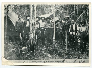
... This is a surveyors' camp in the McCulloch Ranges April... carrying cumbersome surveying and camping equipment, spending ...This is a surveyors' camp in the McCulloch Ranges April, 1897. Surveyors were among the first European settlers to arrive in Australia. A Surveyor-General was present on the First Fleet, as well as the first two ships which landed in South Australia. These men were issued with instructions to record observations in a journal that included the country’s general appearance, its soil, flora and fauna and the customs and language of local inhabitants. The conditions they worked in were harsh and they embarked on journeys with drays carrying cumbersome surveying and camping equipment, spending months camping out in the bush and mapping the land. It was not until well into the second half of the nineteenth century that the professional training of surveyors became mandatory in Australia. This is a pictorial record of a surveyors' camp in the late 19th century.A black / white photograph of a group of men standing at a campsite in the bush. Two tents are in the background.on the front - "Surveyors Camp, McCulloch Ranges" Some names have been added for identification - Bates, Thorn and others which cannot be read.surveyors-camp-mcculloch-ranges land-settlement -
 Orbost & District Historical Society
black / white photograph, 1897
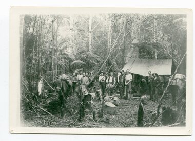
... Link with item 1178. This is a surveyors' camp... of a group of men standing in front of a tent / camp in a dense bush ...Link with item 1178. This is a surveyors' camp in the McCulloch Ranges, Murrangowar, April, 1897. Included in the photograph are: L. Thorn; Pearson; L. Coburn, Clem Bates; Sam Blacklock with a packhorse. They were surveying for a road or railway. Surveyors were among the first European settlers to arrive in Australia. A Surveyor-General was present on the First Fleet, as well as the first two ships which landed in South Australia. These men were issued with instructions to record observations in a journal that included the country’s general appearance, its soil, flora and fauna and the customs and language of local inhabitants. The conditions they worked in were harsh and they embarked on journeys with drays carrying cumbersome surveying and camping equipment, spending months camping out in the bush and mapping the land. It was not until well into the second half of the nineteenth century that the professional training of surveyors became mandatory in Australia.This is a pictorial record of a surveyors' camp in the late 19th century.A black / white photograph of a group of men standing in front of a tent / camp in a dense bush setting.surveyor's-camp-mccullochs-ranges-murrangowar land-settlement -
 Bendigo Military Museum
Photograph - Royal Australian Survey Corps Surveyors in the Field – Project Cutlass, New Guinea, 1956 – 1957
... ) - Photo, colour, 1956. Survey base camp, New Ireland. .6) - Photo...) - Photo, colour, 1956. Survey base camp, New Ireland. .6) - Photo ...This is a set of 23 photographs of surveyors and support staff in the field undertaking tasks in New Guinea 1956 – 1957. The surveyors were employed in the establishment of mapping and geodetic control for Project Cutlass, the “Ship-Shore” survey of the New Ireland province. In this survey operation surveyors used theodolites to observe horizontal and vertical angles and chains to measure base line distances between survey stations. Bob Skitch shown in photo .7P was in the 2nd year of his career in the Australian Army. He achieved the rank of Lieutenant-Colonel, and his last appointment was the CO of the Army Survey Regiment from 1976 to 1980.This is a set of 23 photographs of surveyors and support staff in the field undertaking duties during Project Cutlass located in New Ireland, New Guinea 1956 – 1957. The photographs were printed on photographic paper and are part of the Army Survey Regiment’s Collection. The photographs were scanned at 300 dpi. .1) - Photo, colour, 1956. Surveyors travelling main road from Kavieng to Namatanai, New Ireland. .2) - Photo, colour, 1956. Unidentified surveyors assessing recovery of their vehicle after bridge collapsed on west side of New Ireland. .3) - Photo, colour, 1956. Unidentified surveyors assessing recovery of their vehicle after bridge collapsed over flooded creek on west side of New Ireland. .4) - Photo, colour, 1956. Survey personnel L to R: Bev Uwins, John Lambie, Bob Thompson, New Ireland. .5) - Photo, colour, 1956. Survey base camp, New Ireland. .6) - Photo, black & white, 1956-1957. Geoff Helsham with possible human remains, New Ireland. .7) - Photo, black & white, 1956-1957. Bob Skitch undertaking survey observations using Wild T2 theodolite, New Ireland. .8) - Photo, black & white, 1956-1957. Chas Beach undertaking survey observations using Wild T2 theodolite, New Ireland. .9) & .10) - Photo, black & white, 1956-1957. Kev Parker (cook) New Ireland. .11) - Photo, colour, 1957. Brian Berkery taking a break, Top Manor Island, Lihir Island Group off New Ireland. Latitude -2° 46”, Longitude 152° 40”. .12) - Photo, colour, 1957. Survey base camp L to R: Chas Beach, Bev Uwins, Feni Islands, New Ireland. Latitude -4° 05”, Longitude 153° 45”. .13) - Photo, colour, 1957. A Hous Kiap. (Kiaps, known formally as district officers and patrol officers, were travelling representatives of the British and Australian governments), New Ireland. .14) & .15) - Photo, colour, 1957. L to R: Joe Farrington, Tom Royle Bob undertaking survey observations using theodolites from an improvised timber tower, New Ireland. .16) & .17) - Photo, colour, 1957. US Army ship FS216 used for ship-to-shore triangulation docked at Rabaul, New Britain. .18) - Photo, colour, 1957. US Army ship FS216 used for ship-to-shore triangulation docked at Kavieng, New Ireland. Sight target on top of mast. .19) - Photo, colour, 1957. Survey personnel onboard US Army ship FS392, L to R: Peter Frodsham, Bob Thompson, Doc Reid, John Underwood, remainder unidentified, New Ireland. .20) - Photo, colour, 1957. Survey base line party heading ashore, New Ireland. .21) - Photo, colour, 1957. Survey personnel rowing US Army assault boat L to R: Kev Parker, Chas Beach, folded up survey beacons overhanging stern, New Ireland. .22) - Photo, colour, 1957. Les Bailey onboard US Army ship departing Rabaul, New Britain for Brisbane. .23) - Photo, colour, 1957. Ron Newman onboard US Army ship departing Rabaul, New Britain for Brisbane. Active volcano in background..1P to .23P annotated on back – ‘Operation Cutlass’, personnel names, the year and the location. royal australian survey corps, rasvy, army survey regiment, fortuna, a, army svy regt, asr, surveying -
 Bendigo Military Museum
Photograph - Tasks Demonstrated by Royal Australian Survey Corps Technicians, c1992
... of Military Survey base camp, Sandy Creek, VIC.... Bourne. .16) – Photo, colour, c1992, School of Military Survey ...This is a set of 16 photographs of technicians from the Royal Australian Survey Corps undertaking technical tasks circa 1992. Photos .1P to .9P were taken at the Army Survey Regiment, Fortuna, Bendigo. Photos .10P to .15P of students operating survey equipment, were taken at the School of Military Survey, Bonegilla and survey stations surrounding Lake Hume. The base camp at photo .16P was probably taken at Sandy Creek, near Tallangatta Victoria, during the field phase of a basic or advanced RA Svy training course. This is a set of 16 photographs of technicians from the Royal Australian Survey Corps undertaking technical tasks at the Army Survey Regiment, Fortuna, Bendigo, and the School of Military Survey, Bonegilla c1992. Colour photos are on 35mm slide film and were scanned at 96 dpi. .1) – Photo, colour, c1992, Aerial photography Assessment, SGT Tony Grivell. .2) – Photo, colour, c1992, Aerial photography Assessment, L to R: WO2 Noel McNamara and LCPL Grant Lloyd. .3) – Photo, colour, c1992, Wild PUG4 point transfer device, LCPL Mark Fedden. .4) – Photo, colour, c1992, AUTOMAP 2 Graphic Edit Workstation, unidentified technician. .5) – Photo, colour, c1992, Heidelberg Speedmaster 102 computer-controlled five colour lithographic offset printing press, CPL Nick Vanderzwan. .6) – Photo, colour, c1992, Daylight film contact frame, SPR Ken Labourchardiere. .7) – Photo, colour, c1992, Heidelberg Speedmaster 102 Map Colour Evaluation Workstation, SGT Stuart Ridge. .8) – Photo, colour, c1992, Map proof evaluation, CPL John Bragg. .9) – Photo, colour, c1992, Wohlenberg MCS-2 guillotine, unidentified technician. .10) – Photo, colour, c1992, Wild T2 Theodolite, L to R: SPR Matt Arnold, SPR Kim Baker. .11) – Photo, colour, c1992, Wild T2 Theodolite, L to R: SSGT Bob Bright, SPR Kim Baker. .12) to .14) – Photo, colour, c1992, MRA-7 Tellurometer, CPL Mark Bourne. .15) – Photo, colour, c1992, Plane Tabling, CPL Mark Bourne. .16) – Photo, colour, c1992, School of Military Survey base camp, Sandy Creek, VIC.There are no annotations.royal australian survey corps, rasvy, army survey regiment, army svy regt, school of military survey, fortuna, asr -
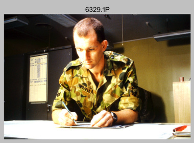
 Bendigo Military Museum
Photograph - A Section, 1st Topographic Survey Troop, Nui Dat, Vietnam, 1969
... Royal Australian Survey Corps troops arrived in South Vietnam... Royal Australian Survey Corps troops arrived in South Vietnam ...This is a photograph of A Section, 1st Topographic Survey Troop taken at Nui Dat, Vietnam in 1969. A nominal roll of personnel and their trade as of the 30th of September 1969, accompanies this photo. Their trades in this photo were as follows - Surveyors Topographic: WO1 Darby Munro, SGT Paddy Strunks, SGT Graeme Birrell, CPL Brian Knight, CPL Colin Laybutt, SPR Roderick Gilbert and SPR Rodney Offer. Draughtsmen Topographic: SGT Terrance Linz, CPL Robert Kay, SPR Peter Aukstinaitis, SPR Lloyd Patterson and SPR Ian Wark. Photographer Cartographic: CPL George Graham. Clerk Admin: CPL Oreste Biziak. Helioworker: CPL Geoffrey White, SPR Lance Percey. Cook AACC: PTE R. Johnston. The first Royal Australian Survey Corps troops arrived in South Vietnam on the 10th of June 1966. This was a detachment from 1st Topographic Survey Troop, which was to give cartographic support to the Australian Task Force. Their main tasks were to establish a Theatre Grid, map compilation and map revision. Engineer Survey Support in the camp and to the civil community and give assistance to the Cordon Search Missions by producing large scale plots from aerial photos with every house and fence etc plotted and then reproduce these by silk screening usually, within a 24-hour period. This support concluded with the withdrawal of Australian troops from Vietnam in 1972. For more information on the career of A Section’s OC MAJ Peter Constantine AM, refer to item 6159P or 6092P. He was the CO of the Army Survey Regiment from 1975 to 1976 and CO of the School of Military Survey (SMS) from 1976 to his retirement in January 1982. His memoirs of active duty in Vietnam ‘Surveyor - Printer Behind the Lines’ was published in 2022. 2IC CAPT Frank Thorogood SB St J’s career culminated at the rank of LTCOL as the CO Army Survey Regiment from 1980 to 1981. More information on the A Section, 1st Topographic Survey Troop and the Army Survey Regiment’s supporting role is provided in pages 89 to 94 of Valerie Lovejoy’s book 'Mapmakers of Fortuna – A history of the Army Survey Regiment’ ISBN: 0-646-42120-4.This is a photograph of A Section, 1st Topographic Survey Troop taken at Nui Dat, Vietnam in 1969. The black and white photograph was printed on photographic paper and is part of the Army Survey Regiment’s Collection. The photograph was scanned at 300 dpi. .1) - Photo, black & white, 1969. Back row L to R: SPR Lance Percey, SPR Bruce Grisdale, SPR Rodney Offer, SPR Roderick Gilbert, CPL Geoffrey White, PTE R. Johnston, CPL Colin Laybutt, SPR Lloyd Patterson. Centre row L to R: SPR Peter Aukstinaitis, SPR Ian Hanna, SPR Ian Wark, CPL Robert Kay, CPL George Graham, CPL Oreste Biziak, CPL Brian Knight. Front row L to R: SGT Terrance Linz, SSGT Gordon Haswell, 2IC CAPT Frank Thorogood SB St J, OC MAJ Peter Constantine AM, WO1 Darby Munro, SGT Paddy Strunks, SGT Graeme Birrell.An A4 nominal roll of personnel and their trade accompanies the photo, as of the 30th of September 1969. A torn paper identifies the personnel in the photo. Annotated on back of photo – ‘Unit Photo – 1 Topo Svy Tp 30 Sept 69’royal australian survey corps, rasvy, army survey regiment, army svy regt, fortuna, asr -
 Federation University Historical Collection
Map, Ballaarat Gold Field, 1861, 21/10/1861
A party of surveyors camped by Yuille's Swamp (later Lake Wendouree) and surveyed the countryside for a map to be produced by the Geological Survey of Victoria. In November 2004 the Central Highlands Regional Library presented a special edition of 200 copies of the 1861 map reproduced from a copy in their collection. Original geological map of Ballarat showing property, waterways, mines, churches, schools, water races, and garden reserves. It was compiled and drawn from the surveys of Mining Surveyors Davidson, Fitzpatrick and Cowan.Compiled & Drawn from the Survey of Mining Surveyors Davidson, Fitzpatrick and Cowan & the Plans in the Surveyor General's Office by J. Brahe, 21st October 1861. R. Brough Smyth, Secretary for Mines. The Honourable J.B. Humffray, M.L.A. Commr of Mines.ballarat, map, davidson, robert brough-smyth, fitzpatrick, cowan, yuille's swamp, public garden reserve, manure depot, black hill, ballarat east, old post office hill, pennyweight hill, claytons hill, golden point, mining, railway, cricket ground, swamp creek, cemetery, sludge reserve, bakery hill, gaelic church, juvenile reformatory, orphanage, specimen hill, eureka lead, cattle yard hill, dalton's flat, chinese village, poverty hill, railway reserve, little bendigo diggings, pound reserve, allied armies, flour mill, agricultural reserve, marsh, survey reserve, survey corps, white flat, yarrowee, yarrowee creek, brache, j. brache, survey, ballaarat gold field 1861 -
Federation University Historical Collection
Book, Jacobs Lewis Vines Architects and Conservation Planners, Historic Sites Survey: Ballarat Study Area, 1980
114 page report on historic sites in the Ballarat region. rhistoric sites, ballarat, wendy jacobs, miles lewis, gary vines, berringa, buninyong, creswick, dunnstown, fiery creek, lal lal, langi logan, cathcart, mount cole, mount egerton, nerrina, gong gong, wombat state forest, railways, explorers routes, early roads, land conservation council, ausralian hertiage commission, department of planning, icomos (burra) charter, nigel lewis, richard aitken, freehold land, public land, langi ghiran, new jubille mine, birthday tunnel mine, pitfield plains, smythesdale, buninyong company, mount clear, mt clear, canadian gully, warrenheip distillery, thomas mitchell, waterloo, trawalla, beaufort, raglan, internment camps, forestry, mining, mining, mt egerton, mary hollick collection -
 Federation University Historical Collection
Map, Ballaarat Gold Field, 1861
A party of surveyors camped by Yuille's Swamp (later Lake Wendouree) and surveyed the countryside for a map to be produced by the Geological Survey of Victoria. In November 2004 the Central Highlands Regional Library presented a special edition of 200 copies of the 1861 map reproduced from a copy in their collection. Original 1861 map of Ballarat showing streets and leads. Blue dots indicate gold leads, and red lines indicate auriferous quartz reef and outcrops of quartz veins."Compiled & Drawn from the Survey of Mining Surveyors Davidson, Fitzpatrick and Cowan & the Plans in the Surveyor General's Office by J. Brahe, 21st October 1861. R. Brough Smyth, Secretary for Mines. The Honourable J.B. Humffray, M.L.A. Commr of Mines.”ballarat, map, ballarat east, lake wendouree, survey, mines, robert davidson, ballarat gold field 1861, yuille's swamp, wendouree swamp, little bendigo diggings, gold leads, old post office hill, specimen hill, bakery hill, black hill, dead horse creek, brown hill, pennyweight hill, clayton hill, soldiers hill, golden point, gum tree flat, white flat, poverty hill, chinese village, robert brough smyth, ballarat map 1861, ballaarat vineyard, dead horse gully, deadhorse creek, invermay, black hill flat, gaelic church, police reserve, magpie range, dalton's flat, caadian lead, rifle butts, powder magazine, bathing house, government camp, gold office, chinese, llanberrris, victoria theatre, charlie napier hotel, united states hotel, grape's hoel, clayton's hill, cattleyard hill, free trade hotel, esmond lead, bakery hill, black hill lead, juvenile reformatory, ballarat orphanage, lady barkly lead, triffet's slaughter yard, little bendigo, melbourne road -
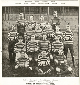 Federation University Historical Collection
Book, Ballarat School of Mines Students' Magazine, 1907-1909, 1907-9
Bound volume of the Ballarat School of Mines Students' Magazine for 1907-1909. Articles include the location and pegging of a tramway Route, the transmission of Power by Rope Driving by A.E.C. Kerr, A visit to the Briseis Mine, and New Brothers' Home, Mining Engineers in Tasmania, Obituaries for David Ham and Matthew Lyndsay, Pioneer Mining at Leichhardt, Automatic Ore Feeders and Chacedony Park by J.H. Adams. Images include the Ballarat School of Mines Football Team and the Ballarat School of Mines Sports Committee. 1907 * Hubert Krause 1908 * The location and Pegging of a Tramway Route by Yamba * The Unity of things by John Brittain * The transmission of power by Rope Driving, by A.E.C. Kerr * A visit to the Briseis Mine, and New Brothers' Home (includes photographs) * Mining Engineers in Tasmania * Limericks Sluiced at Snake Valley * David Ham Obituary * Matthew Lyndsay Obituary * Some Bunsen Memories by Professor Alfred Mica Smith * Geological Camp to Daylesford * Practical Mathematics by Hubert F. Hall * Pioneer Mining - Leickhardt * Automatic Ore Feeders * A Unique Ore Deposit (Lucknow Goldfield, NSW) * A country Ramble * The Alkaline Titration for Zinc * Chalcedony Park, Arizona, United States of America by J.H. Adams * Notetaking at Lectures * Smelter Cost-Keeping by Oliver E. Jaeger * Benefits of Physical Culture * Mineral Tasmania and its Wonderful Resources by F.F. Bradford * A holiday Trip to Queensland * The Compression of Air as Applied to Mining * Machine V Hand Drilling * The mining in the Malay States * William Thomas Grownow Obituary (includes image) * Timbering Stopes (Includes images) * Trip to Melbourne * Two Problems of Alluvial Mining by Richard Hain * The Berry Leads (includes plan of mines) * Black Pudding Supper * Observations for Meridian * NOtes on Coking Plants (includes plan) * How Old is the Earth * Conglomerations * A Pat Formula * The making of a Suitable Muffle for General Assay Work * Reduction of Gold Chloride by Charcoal * Chemical Definitions * Old Boys (R.J. Allen, W.B. Blyth, F. Brinsden, Lindsay D. Cameron, George W. Cornwell, John M. Currie, C.M. Harris, T. Wighton-Hood, W. Lakeland, W.S. Macartney, Fred A. Marriott, Karl B. Moore, G.E. Sander, Sherb. H. Sheppard, Norman S. Stuckby, John Sutherland, Lewis A. Westcott, Walter White, O.C. Witherden, Gerald Young) 1909 * The Graduates Problem * An Interesting Nevada Cyanide Plant (Bamberger De Lamar Gold Mines) * Easter Geological Camp to Ingliston * New Methods for the Volumetric Estimation of Lead * William Charles Kernott Obituary * Mount Morgan Mine by G.W. Williams * Tin Dredging at Tingha, New South Wales * Notes on the Iodide estimation of Copper * Photograph of the Ballarat School of Mines Students' Association Committee * The Importance of Mine Ventilation to the Students by F. Howells * Life in Mining Camp * Wise Words to Mining School Students * Military Search Lights * Gleaning s on resistance * Ministerial Visit to the Ballarat School of Mines by the Hon. A.A. Billson, Minister of Education , accompanied by Frank Tate, Director of Education. * Picture Making in Photography Composition * Mountains of Fire * A Walking Engine - New Military Machine - Guns into Action - Caterpillar No. 1. (Tank) * Fireless Locomotives * Elmore Concentrating Process (includes plan of Elmore Concentrator) * Mount Pani Limited * Surveying for Irrigation * Weights and Measures * Carbon Monoxide * Joseph Francis Usher obituary * The Problem of the Metalliferous Veins * Ballarat School of Mines Ambulance Class * Treatment of Gold in a battery Without the Use of Copper Plates by E.C. Hurdsfield * Meteorites * Werribee Gorge * Dredging in the Ovens Valley * Electrical Chatter - Electrocution by an Imaginary Eye-Witness * The Electric Furnace in Iron Metallurgy ballarat school of mines, ballarat school of mines football team, football, sports, tramway, mining engineers, david ham, matthew lyndsay, jack adams, berry lead, hepburn consuls, madame berry, west ristori, ristori no 1, allendale, dyke's co, charleson's mill, australian extended, mining, r.j. allen,, w.b. blyth, f. brinsden, lindsay d. cameron, george w. cornwell, john m. currie, c.m. harris, t. wighton-hood, w. lakeland, w.s. macartney, fred a. marriott, karl b. moore, g.e. sander, sherb. h. sheppard, norman s. stuckby, john sutherland, lewis a. westcott, walter white, o.c. witherden, gerald young, ballarat school of mines students' association, hubert krause, krause, vfl, afl -
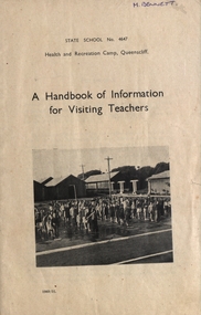 Federation University Historical Collection
Booklet, J.J. Gourley (Government Printer), A Handbook of Information for Visiting Teachers, 1951
... about Health and Recreation Camp Queenscliff M.Bennett written ...A 55 page booklet about Health and Recreation Camp Queenscliff M.Bennett written on the front cover and M.J. Bennett 19 Waller Ave Ballarat written inside front cover.handbook, health and recreation camp, queenscliff, visiting teachers, margaret bennett, history of camp site, geological survey of queenscliff -
Marysville & District Historical Society
Article (item) - Book Extract, Aboriginal History, Unknown
An extract from a book regarding a brief history of the Kulin nation of the North Central district of Victoria.An extract from a book regarding a brief history of the Kulin nation of the North Central district of Victoria. This history covered is both prior to European history and post-European history. The extract also covers current (1991) status of Aboriginal affairs and European settlement of the area.kulin nation, woiworung, taungurong, bunurong, watherong, jajowrong, wurrundjeri-willam, waring-ilam-balluk, goulburn valley, acheron valley, upper goulburn district, eildon-thornton, eildon homestead, o'rourke, thornton, assistant protector thomas, yarra valley, kilmore, mount william, jt gellibrand, william buckley, major mitchell, port phillip, murray river, yorta yorta, yowung-illam-balluk, waring-illam-balluk, ngurai-illam-wurrung, kurnai nation, protectorate system, victoria, george robinson, chief protector, willam thomas, james dredge, edward parker, charles sievewright, central board for the protection of aborigines, presbyterian mission, anglican mission, moravian mission, wonga, munnarin, beaning, murrin murrin, parugean, baruppin, koo-gurrin, acheron river, little river, acheron run, peter snodgrass, stephen jones, barak, dividing range, black spur, watts river, badger creek, healesville, coranderrk, victorian christmas bush, aboriginal and torres strait islander heritage protection act 1984, archaelological and aboriginal relics preservation act 1972, camp jungai, rubicon, warrawa college, victorian archaeological survey, hume and hovell, molesworth, broadford, william hamilton, alexandra, mansfield, avenel, tallarook, worrough, john cotton, trawool valley, seymour, pyalong, gold mining, central victoria, strath creek, reedy creek, yea, jamieson, marysville, jordan goldfields, comet mine, wandong, melbourne-albury railway, rabbit plague, narbethong, lord kitchener, puckapunyal military camp, 1944 decentralisation policy, eildon weir, hume freeway bypass, timber industry, australian paper manufacturers mill -
 Kiewa Valley Historical Society
Black and white photograph of Surveyor's Camp, 1938, Kiewa River and surveyor's Camp 25/8/38, 25/08/1938
Surveying under the prevailing conditions at this time was an arduous and demanding task. There were no roads beyond Tawonga and access was by bridle tracks, on foot or horseback. This camp was to provide accommodation to those men who were surveying the road from South Tawonga to the Bogong High Plains which was commenced in April, 1938. The actual work was undertaken by the Country Roads Board, on behalf of the State Electricity Commission, using three Caterpillar diesel crawler tractors equipped with Kay Bruneriei (Brunner) lhydraulically operated trailbuilders (angle dozers)This photograph shows the primitive living conditions that were endured by those carrying out the initial field investigations and surveys for the Kiewa Hydro Electric Scheme. It is possibly one of the few photographs in existence of this camp and of the very rustic timber foot bridge across the West Kiewa river. It has been taken from approx. 100m up Simmonds Creek Road. A black and white photograph showing a small, timber foot bridge across the West Kiewa River. There is a man standing on the bridge and two small huts on the far side of the river, against a backdrop of Mt. Beauty and Mt. Bogong.At the top of the photograph, handwritten in black ink is the inscription "Kiewa River and Surveyor's Camp 25/8/38". The number 4 is stamped towards the right upper corner. On the back, in a circle, about 1.3cm in diameter, are the words "Kodak Print". The word "Velox" is faintly discernible on the back as well.surveyor, tawonga, west kiewa river, bridge, camp, secv -
 The Beechworth Burke Museum
Photograph, c1930
Taken on 25 October 1930, various houses with the Hume Dam under construction are depicted in the background. The construction of the Hume Dam took place from 1919 to 1936. At the time of construction, it was the second largest dam in the world. It was also one of the earliest civil projects developed after the Federation. Some of the Dam workers consisted of World War I veterans. Dam workers often settled their families in Mitta Junction Village and Wodonga. Archaeological surveys were completed by Austral Archaeology, which was done when the Department of Land & Water Conservation was doing work to improve Hume Dam. The archaeological report that came out of the survey recommended three sites of interest where archaeological excavation should be done: Camp Ganger’s Quarters, Stableman’s Quarters, and the Industrial Dump. The excavation uncovered artefacts. Mitta Mitta: Mitta Mitta is situated between Mount Welcome and Mount Misery. It is named after the river that explorers Hume and Hovell discovered in 1824. The town would eventually become a huge gold mining town. Mitta Mitta is called Midamodunga by the local Indigenous peoples Wodonga: Wodonga is situated on the Murray River and is part of North East Victoria. Hume and Hovell: Hamilton Hume (1979-1873) and William Hilton Hovell (1786-1875). W. H. Hovell was born in Norfolk England and Hume was born in Parramatta, New South Wales Hovell and Hume undertook an exploration journey in 1824 and thought they discovered a river, which turned out to be the Murray River. They returned home in 1825, but returned to the area in 1826 and discovered coal in the area. This photo is historically significant as it shows the Hume Dam under construction in 1930. The Dam was named after Hamilton Hume, who is an important historical figure for this area as he helped discover the area where resources were found.Sepia rectangular photograph printed unmountedReverse: 84-19-5 / 1997.3185/ Values & spillway. / When completed the wall / will be as high as the / scaffolding. [featuring trademark: kodak print]construction, houses, veterans, mitta junction village, hume dam, world war i, federation, wodonga, archaeological survey, excavation, austral archaeology, department of land & water conservation, camp ganger's quarter's, stableman's quarters, industrial dump, artefacts, mitta mitta, mount welcome, mount misery, murray river, hamilton hume, william hilton hovell, hume and hovell expedition -
 The Beechworth Burke Museum
Photograph, c1930
Taken on 25 October 1930, various houses with the Hume Dam under construction are depicted in the background. The construction of the Hume Dam took place from 1919 to 1936. At the time of construction, it was the second largest dam in the world. It was also one of the earliest civil projects developed after the Federation. Some of the Dam workers consisted of World War I veterans. Dam workers often settled their families in Mitta Junction Village and Wodonga. Archaeological surveys were completed by Austral Archaeology, which was done when the Department of Land & Water Conservation was doing work to improve Hume Dam. The archaeological report that came out of the survey recommended three sites of interest where archaeological excavation should be done: Camp Ganger’s Quarters, Stableman’s Quarters, and the Industrial Dump. The excavation uncovered artefacts. Mitta Mitta: Mitta Mitta is situated between Mount Welcome and Mount Misery. It is named after the river that explorers Hume and Hovell discovered in 1824. The town would eventually become a huge gold mining town. Mitta Mitta is called Midamodunga by the local Indigenous peoples Wodonga: Wodonga is situated on the Murray River and is part of North East Victoria. Hume and Hovell: Hamilton Hume (1979-1873) and William Hilton Hovell (1786-1875). W. H. Hovell was born in Norfolk England and Hume was born in Parramatta, New South Wales Hovell and Hume undertook an exploration journey in 1824 and thought they discovered a river, which turned out to be the Murray River. They returned home in 1825, but returned to the area in 1826 and discovered coal in the area.This photo is historically significant as it shows the Hume Dam under construction in 1930. The Dam was named after Hamilton Hume, who is an important historical figure for this area as he helped discover the area where resources were found.Sepia rectangular photograph printed unmountedReverse: 84-19-2/ 1997.3188/ These are the four / release valves they are / not always open (illegible) this / when closed the water flows / over the spillway. [featuring trademark: kodak print] photograph number: 354construction, houses, veterans, mitta junction village, hume dam, world war i, federation, wodonga, archaeological survey, excavation, austral archaeology, department of land & water conservation, camp ganger's quarter's, stableman's quarters, industrial dump, artefacts, mitta mitta, mount welcome, mount misery, murray river, hamilton hume, william hilton hovell, hume and hovell expedition